

Community
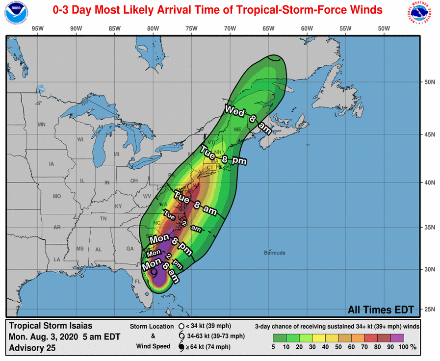
Tropical Storm Watch issued for northern Connecticut, Rhode Island and Massachusetts
A Tropical Storm Watch has been issued for northern Connecticut, Massachusetts, and Rhode Island by the National Weather Service.
A Tropical Storm Watch means tropical storm-force winds are possible within the next 48 hours.
Winds are currently expected to be 20-30 mph with gusts to 45 mph.
NWS recommends to plan for hazardous wind of equivalent tropical storm force.
Efforts to protect property should now be underway. Prepare for limited wind damage.
![]()
Potential Impacts
– Damage to porches, awnings, carports, sheds, and unanchored mobile homes. Unsecured lightweight objects blown about.
– Many large tree limbs broken off. A few trees snapped or uprooted, but with greater numbers in places where trees are
shallow rooted. Some fences and roadway signs blown over.
– A few roads impassable from debris, particularly within urban or heavily wooded places. Hazardous driving conditions on bridges and other elevated roadways.
– Scattered power and communications outages.

– Peak Rainfall Amounts: Additional around 1 inch
-Potential for localized flooding rain
– PLAN: Emergency plans should include the potential for localized flooding from heavy rain.
– PREPARE: Consider protective actions if you are in an area vulnerable to flooding.
– ACT: Heed any flood watches and warnings.
– Localized rainfall flooding may prompt a few evacuations.
– Rivers and tributaries may quickly rise with swifter currents. Small streams, creeks, and ditches may become swollen and overflow in spots.
– Flood waters can enter a few structures, especially in usually vulnerable spots. A few places where rapid ponding of water occurs at underpasses, low-lying spots, and poor drainage areas. Several storm drains and retention ponds become near-full and begin to overflow. Some brief road and bridge closures.


You must be logged in to post a comment Login