
Community
Winter Weather Advisory cancelled for southeastern Massachusetts
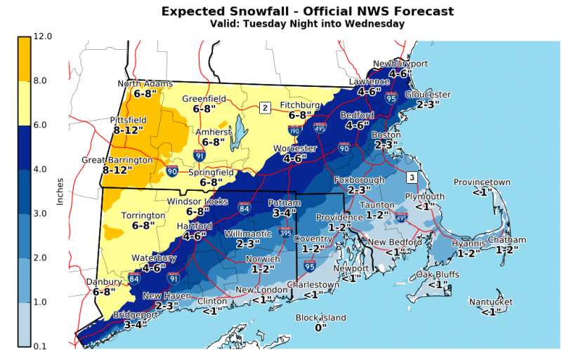
Since this morning’s Situational Awareness Statement, the National Weather Service has downgraded the Winter Storm Warning for portions of eastern Massachusetts, including greater Boston and the Boston-Providence corridor, to a Winter Weather Advisory. The Winter Weather Advisory previously in effect for portions of southeastern Massachusetts has been cancelled.
Light snow will overspread the entire region before dawn tomorrow morning. In central and western Massachusetts, the heaviest snowfall is forecast to occur between 4 and 10 AM. In eastern Massachusetts, the heaviest snow will fall between 7 and 9 AM before transitioning to a wintry mix and then to all rain by 11 AM in the greater Boston area and to the south of the Boston to Providence corridor. Snow and rain will taper off across the region Wednesday afternoon.
Total snowfall accumulations are forecast to be a widespread 5-9 inches in western and central Massachusetts and portions of the northeast, with locally higher amounts possible in far western Massachusetts. Only 1-4 inches of snow is forecast for coastal areas of the northeast and in and to the south of the greater Boston area due to the expected changeover to rain Wednesday morning.

Snowfall is expected to result in reduced visibility and hazardous travel on snow-covered roads, particularly during the Wednesday morning commute.
The Flood Warning for Bristol and Plymouth Counties is now in effect until 7:00 a.m. Wednesday.


-

 Community6 years ago
National Shrine of La Salette Festival of Lights 2017 set to begin
-

 Community6 years ago
Massachusetts State Police looking for good home for retired dogs
-

 Crime6 years ago
Fall River ranked most dangerous city in Massachusetts according to report
-

 latest6 years ago
Durfee student allegedly overdoses on marijuana
-

 Community6 years ago
Video of Fall River Police goes viral
-

 Causes6 years ago
Missing Fall River woman found deceased
-

 Crime6 years ago
Fall River Police add names to most wanted list
-

 Causes6 years ago
Fall River teenager reported missing has been found
