

Community
Winter Storm Watch issued as preliminary forecast shows several inches of snow expected in southern Massachusetts
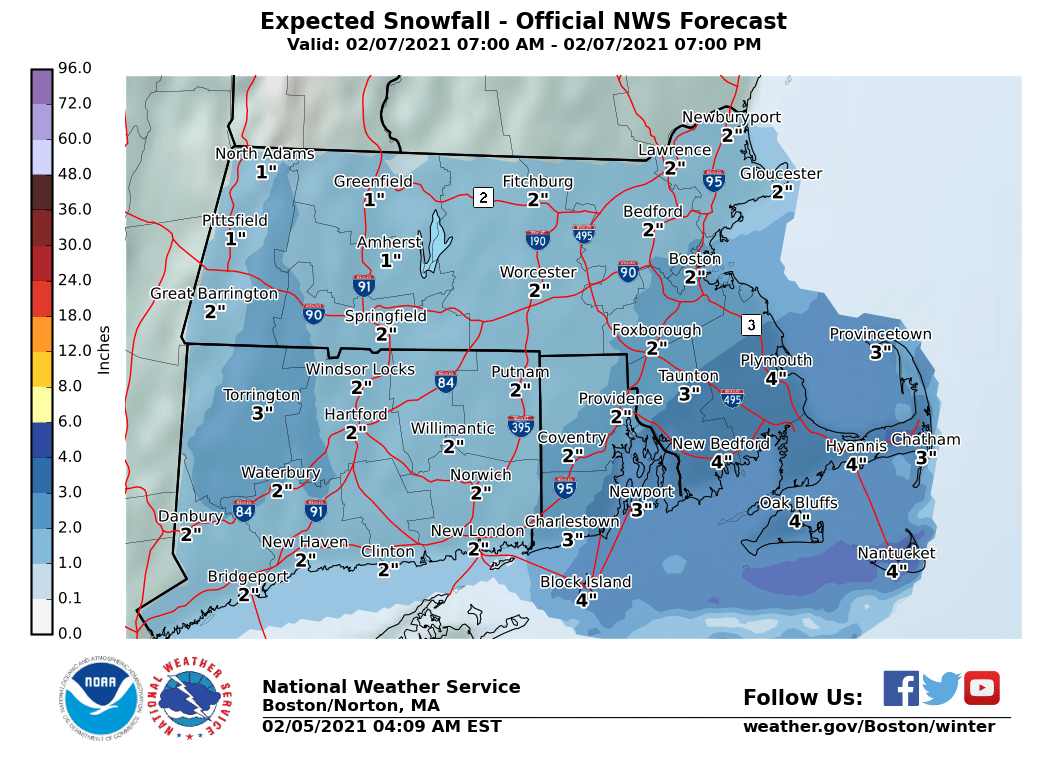
A Winter Storm Watch has been issued for portions of southeastern Massachusetts and northern and southern Rhode Island as several inches of snow are expected.
The Winter Storm Watch is in effect from February 7, 07:00 AM EST until February 8, 01:00 AM EST
Heavy snow possible is possible as total snow accumulations of 4 to 8 inches possible. Winds could gust as high as 40 mph.
According to the National Weather Service, a period of accumulating snow is possible on Sunday depending on how far north a low pressure system tracks. It is possible that most of the region is spared accumulating snow if the system ends up tracking further south. However, a track further north would bring the potential for a plowable snowfall to much of southern New England. At this time, the best chance for accumulating snow is south of the Massachusetts turnpike and particularly near the south coast.
The forecast:

This Afternoon
Rain likely, mainly before 3pm. Patchy fog after 4pm. Otherwise, cloudy, with a high near 44. Southwest wind 8 to 10 mph, with gusts as high as 24 mph. Chance of precipitation is 60%. New precipitation amounts of less than a tenth of an inch possible.
Tonight
Cloudy during the early evening, then gradual clearing, with a low around 29. West wind 5 to 9 mph.
Saturday
Sunny, with a high near 40. West wind 9 to 18 mph, with gusts as high as 36 mph.
Saturday Night
Increasing clouds, with a low around 25. West wind 5 to 8 mph becoming calm in the evening.
Sunday
Snow likely, mainly between 11am and 2pm. Cloudy, with a high near 34. East wind 3 to 7 mph.
Sunday Night
Partly cloudy, with a low around 20. Northwest wind 6 to 9 mph.


You must be logged in to post a comment Login