
Community
Snow forecast across area; up to 18 inches in northern Massachusetts
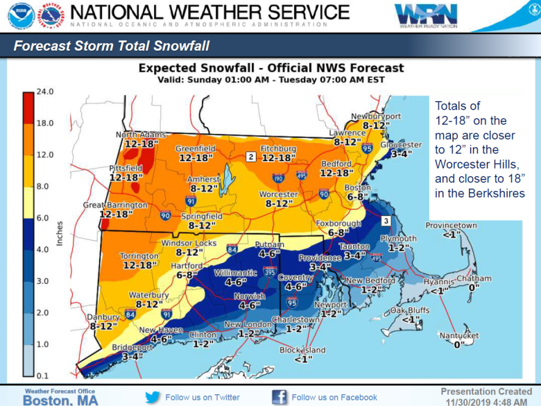
The National Weather Service (NWS) is forecasting a significant snow storm with impactful accumulations possible, beginning Sunday afternoon into Tuesday. This storm will bring heavy snowfall to most of Massachusetts (MA) except over portions of southern New England, especially eastern MA, where a wintry mix may occur.
Snowfall accumulations could be in excessive of 12 inches across western and central MA.
Accumulations of 4 to 8 inches are possible along the I-95 corridor in northeast MA, including Boston area, except 2 to 5 inches of snow is possible along the immediate shoreline. A wintry mix with sleet and rain is possible at times.
1-2 inches/hour snowfall rates Sunday night are likely with 6 or more inches of snow accumulation expected for much of Massachusetts by the Monday morning commute.
A wintry mix is also expected in southeast MA, lesser accumulations are expected due to mixing with or a changeover to rain. Snowfall amounts mainly 1 to 4 inches are possible.
Light to moderate snow will continue Monday into early Tuesday.
There is some uncertainty due to the exact track of the storm and accumulation amounts due to the following factors.
-East flow becoming northeast along coast, with water temperatures of 48 degrees. This could lead to a situation where eastern parts of Boston are primarily rain while the western parts of Boston and Metro-West are heavy snow.
-Exact location/timing of transition from snow to freezing rain/rain still uncertain. This could cut down snow amounts if occurs more rapidly than expected.
-Snowfall rates Monday into early Tuesday are uncertain. Steady, but more manageable snowfall accumulations expected. Storm totals by Tuesday morning could be in excess of one foot in areas that remained all snow.

-Storm surge up to 2 feet is expected. However with very low astronomical tides, any coastal flood issues are expected to be limited to splash over around the times of high tide.
Potential Hazards and Impacts
Heavy Snow
1-2” per hour snowfall rates possible Sunday; light to moderate snow will continue Monday into Tuesday.
Hazard travel conditions on all surfaces, treated or untreated; avoid travel if possible.
Light Freezing Rain
A period of light freezing rain (less than 0.2 inches) in the interior portions of southern New England- mainly interior southeast MA.
Locally hazardous travel conditions on untreated bridges, overpasses, and/or secondary roads.
Wind Gusts
Wind gusts of 30-40 MPH Sunday night into Tuesday along coast. Interior portions of the state may experience wind gusts of 20-25 MPH.
Loose objects may become airborne; isolated tree damage.


You must be logged in to post a comment Login