

Community
Heavy rain, wind, flooding expected in Massachusetts
The National Weather Service’s confidence is increasing with regard to coastal flooding, strong winds, heavy rain, and interior snow across the higher terrain Friday through Saturday. Here’s a rundown of the various hazards:
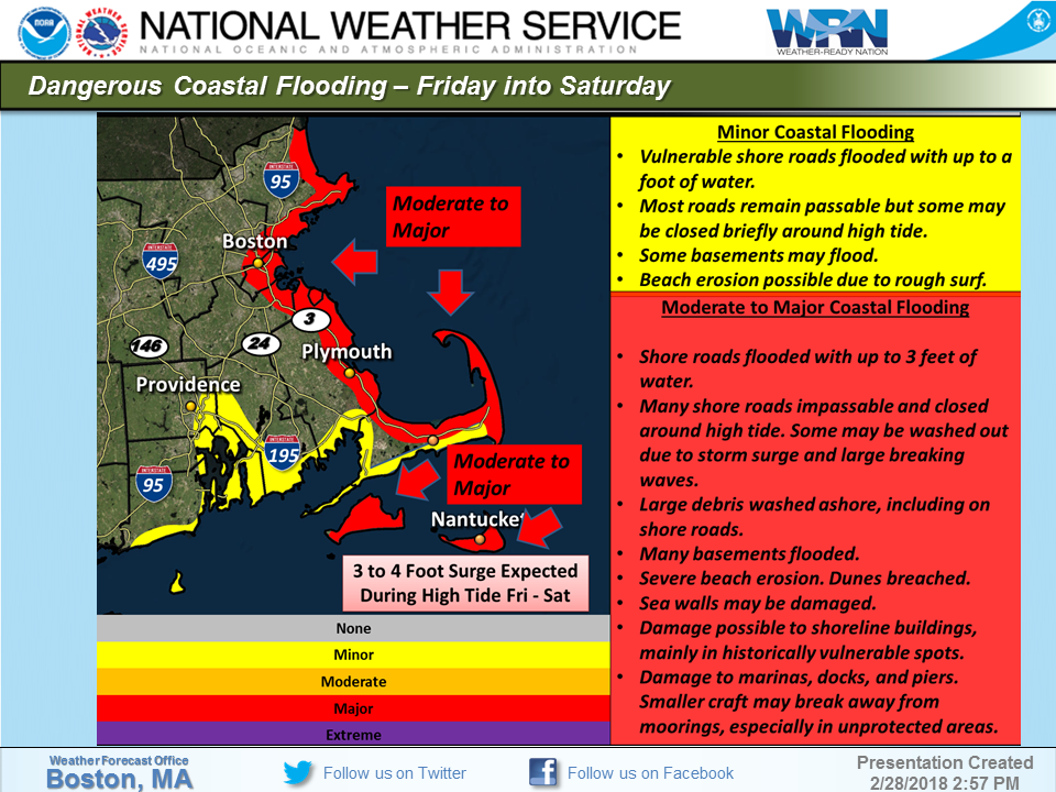
By far, the greatest concern is for the possibility of serious coastal flooding along the eastern Massachusetts coast. Coastal residents need to take precautions NOW, before the storm hits!
1) Coastal Flooding:
Moderate to major coastal flooding is expected along the entire stretch of the eastern Massachusetts coastline, from Newburyport to Boston and Cape Cod and the Islands.
This means significant tidal flooding is expected over the high tide cycles from Friday through Saturday. Potential impacts include:
* Shore roads flooded with up to 3 feet of water.
* Many shore roads impassable and closed around high tide.
* Some roads may be washed out due to storm surge and large breaking waves.
* Large debris washed ashore, including on shore roads.
* Many basements flooded.
* Severe beach erosion. Dunes breached.
* Sea walls may be damaged.
* Damage possible to shoreline buildings, mainly in historically vulnerable spots.
* Damage to marinas, docks, and piers. Smaller craft may break away from moorings, especially in unprotected areas.
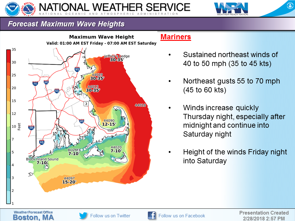
2) Life-Threatening Conditions for Mariners:
The combination of Storm Force (50-60 knot) gusts and seas of over 30 feet offshore will result in life-threatening conditions for those who remain at sea during this storm on the Massachusetts and Rhode Island coastal waters (and farther offshore) Friday into early Sunday. To be safe, plan to return to port by Thursday night.

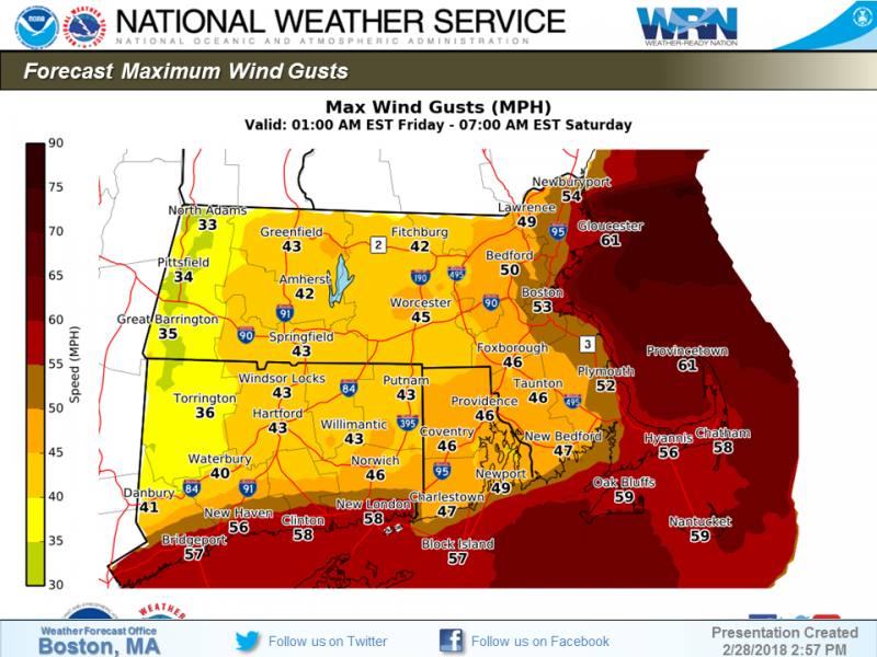
3) Strong and Possibly Damaging Winds:
Gusts of 40 to 60 mph are expected, with the strongest gusts in Rhode Island as well as central and eastern Massachusetts, where scattered power outages are more likely to occur from downed trees or large branches.
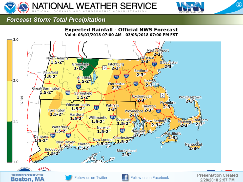
4) Heavy Rain and Flooding:
Rainfall of 1 to 3 inches is expected over most of the area. Flooding of rivers, streams, and urban areas is possible, especially in Rhode Island and eastern Massachusetts where the highest rainfall totals should occur.
5) Interior Snow:
It should be cold enough across the higher terrain near the Berkshires and in northern Worcester County for wet snow to accumulate. Our latest forecast is for 1 to 3 inches of snow in these areas.


You must be logged in to post a comment Login