

Community
Heavy Rain, Damaging Winds and Flooding Forecast for This Afternoon and Monday
A powerful storm is forecast to impact Massachusetts starting this afternoon and lasting into Monday.
The National Weather Service has provided the following headlines concerning this storm:
A powerful storm is forecast to impact Massachusetts starting this afternoon and lasting into Monday.
We have a High Wind Warning from Sunday at 6:00PM to 6:00 AM Monday
We have a Storm Warning from 6:00PM Sunday to 8:00AM Monday
We also have a Flash Flood Watch from 6:00AM Sunday to 6:00AM Monday
The National Weather Service has provided the following headlines concerning this storm:
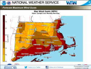
Strong to Damaging Winds
· HIGH WIND WARNING in effect tonight for all of Southern New England.
· Coastal locations including the Boston to Providence corridor will experience the greatest impact
· Tonight into Monday
· Southeasterly gusts as high as 40 to 65 mph tonight
· Westerly gusts as high as 40 to 50 mph Monday
· Widespread tree damage likely along with scattered to numerous power outages

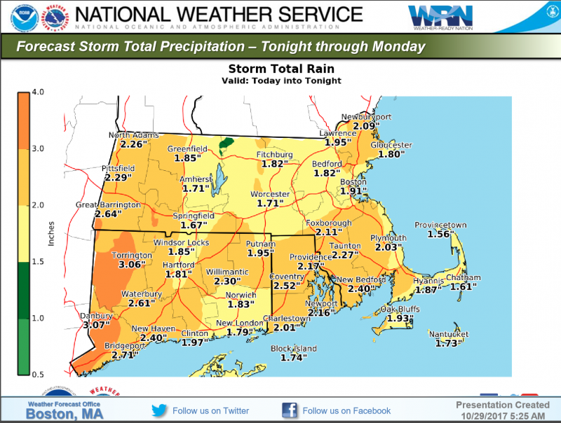
Heavy Rainfall and Flood Potential
· All of Southern New England, however western CT/MA under greatest threat with a secondary max of heavy rain across eastern MA
· Beginning tonight through Monday, though heaviest rain late today into tonight
· Widespread 1 to 2 inches forecast with locally higher amounts of 3 to 4 inches
· Urban / street flooding threat mainly; risk of small stream flooding over western CT/MA
· FLASH FLOOD WATCH in remains in effect, into tonight
· Still some uncertainty on the exact interaction with developing coastal storm over the Mid Atlantic today and Tropical Storm Philippe. If drawn more into the storm system, wind and rainfall impacts could be greater.
· Low risk of a few strong to perhaps severe thunderstorms tonight across RI and eastern MA.
Storm Impacts
Damaging winds may result in widespread tree damage, numerous power outages, and isolated structural damage. The heaviest winds and associated damage will be in coastal areas and southeast MA, including the Cape and Islands.
Flash flooding in urban and poor-drainage areas, including streets and in homes and businesses, is possible. The threat of flash flooding is highest in western Massachusetts, but also exists in eastern MA.
Small stream flooding is possible, particularly in western MA, this afternoon and tonight. Risk of minor flooding along main stem rivers starting on Monday. See River Forecast graphic below.
Thunderstorms and lightning strikes are possible.


You must be logged in to post a comment Login