
Community
Flash Flood Watch issued, high winds expected throughout Southern New England
According to the National Weather Service, a Flash Flood Watch has been issued along with a forecast of strong, possibly damaging, winds.
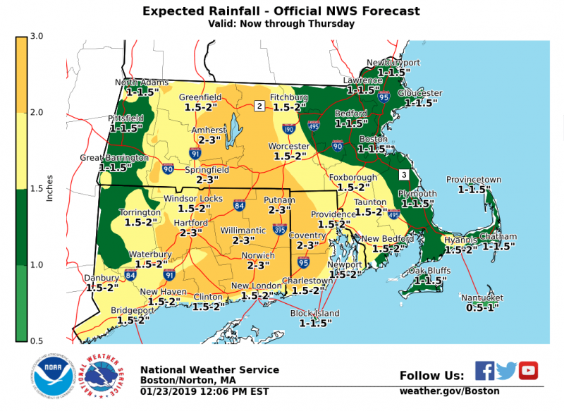
With a forecast of heavy rainfall and snow melt, expect widespread flooding issues throughout Southern New England. Urban areas, basements, small-streams & tributaries, expect the possibility for areas to become inundated.
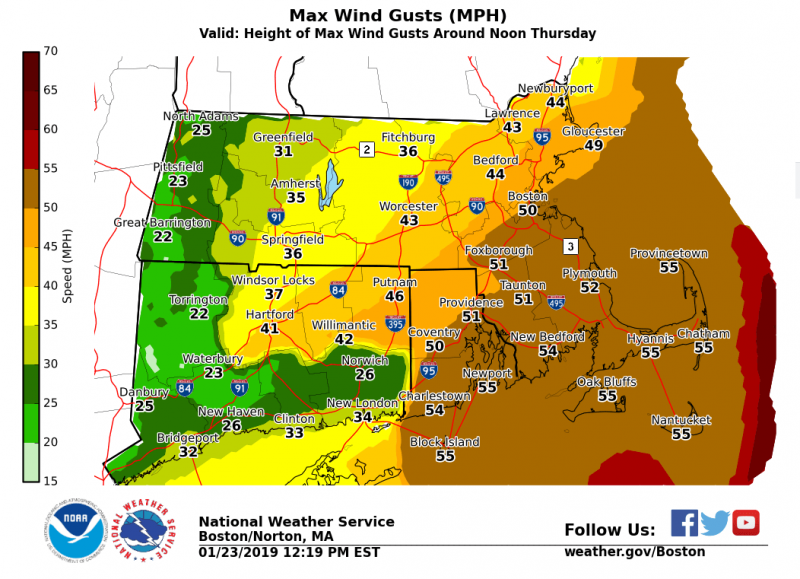
Strong to damaging winds forecast with gusts up to 55 mph. Height of the winds are expected to be at noon Thursday. There is the potential for downed limbs, trees, & power lines. Scattered power outages expected. HIGH WIND WATCH posted for coastal MA & RI.
Potential for storm force winds & seas up to 15 feet centered around noon Thursday into Thursday afternoon. Hazardous wind & wave conditions expected for any and all boaters out on the waters.
The Flash Flood Watch is in effect for portions of northern Connecticut, Massachusetts, and Rhode Island, including the following areas, in northern Connecticut, Hartford, Tolland, and Windham. In Massachusetts, Barnstable, Bristol, Norfolk, Plymouth, and Suffolk. In Rhode Island, Bristol, Kent, Newport, Providence, and Washington from Thursday morning through Thursday evening.

Rain will overspread southern New England tonight and become heavy at times on Thursday. By the time the rain tapers off by early Thursday evening, 1 to 2 inches of rain are anticipated with locally higher amounts possible.
The heavy rain combined with snowmelt will result in the potential for areas of significant urban street flooding. In addition…some small river and stream flooding is possible.
A Flash Flood Watch means that conditions may develop that lead to flash flooding. Flash flooding is a very dangerous situation. You should monitor later forecasts and be prepared to take action should Flash Flood Warnings be issued.


You must be logged in to post a comment Login