

Community
Enjoy the sun as plenty of rain, some sleet is headed our way
Enjoy the sun taking place this weekend as a good amount of rain and some sleet is headed our way.
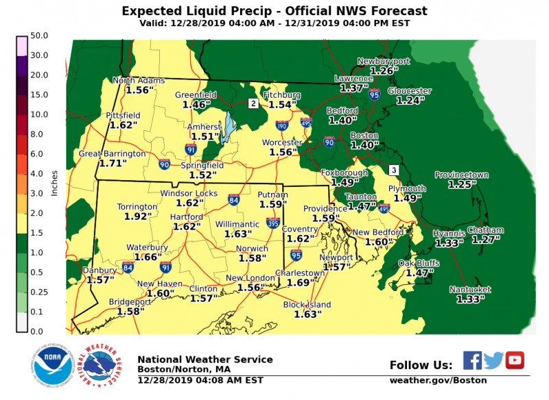
According to the National Weather Service, a prolonged mixed precipitation event will be taking place for Northern CT & interior MA from Sunday night into Tuesday. A significant ice storm is possible north and west, leading to power outages & downed trees. Southern Rhode Island and southern Massachusetts is expected to see a mix of rain and sleet. Expect a slow Monday morning commute.
The current forecast:
Tonight
Mostly clear, with a low around 27. West wind 5 to 7 mph.
Sunday
Mostly sunny, with a high near 41. Northwest wind 5 to 7 mph becoming calm in the afternoon.

Sunday Night
Rain before 1am, then rain and sleet. Low around 32. Light and variable wind. Chance of precipitation is 100%. Little or no sleet accumulation expected.
Monday
Rain and sleet, becoming all rain after noon. High near 39. East wind 6 to 9 mph. Chance of precipitation is 100%. Little or no sleet accumulation expected.
Monday Night
Rain likely. Cloudy, with a low around 34. East wind around 8 mph. Chance of precipitation is 70%.
Tuesday
Rain likely, mainly before 8am. Mostly cloudy, with a high near 47. East wind 5 to 9 mph becoming west in the afternoon. Chance of precipitation is 60%.


You must be logged in to post a comment Login