

Community
Area placed in cone of uncertainty for tropical storm soon to be hurricane
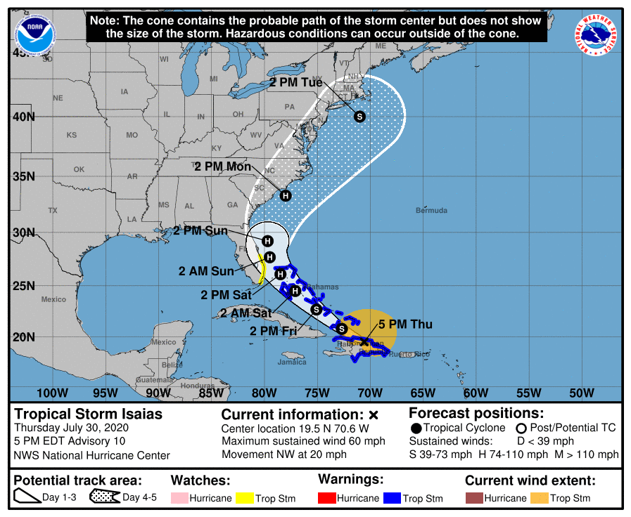
While the storm is a long way away from New England and much can change in the coming days, the NOAA has issued a Tropical Storm Warning and Watch along with a new cone of uncertainty that places our area in it.
Tropical Storm Isaias is expected to become a hurricane on Friday and the NOAA National Hurricane Center has issued the following update.
A Tropical Storm Warning is in effect for…
* Dominican Republic entire southern and northern coastlines
* North coast of Haiti from Le Mole St Nicholas eastward to the northern border with the Dominican Republic
* Turks and Caicos Islands
* Southeastern Bahamas including the Acklins, Crooked Island, Long Cay, the Inaguas, Mayaguana, and the Ragged Islands * Central Bahamas, including Cat Island, the Exumas, Long Island, Rum Cay, and San Salvador
* Northwestern Bahamas including Andros Island, New Providence, Eleuthera, Abacos Islands, Berry Islands, Grand Bahamas Island, and Bimini.
A Tropical Storm Watch is in effect for…
* East coast of Florida from Ocean Reef to Sebastian Inlet
The Tropical Storm Warnings for the central and northwest Bahamas may be upgraded to Hurricane Warnings this evening or tonight.
Tropical storm conditions will continue to spread across portions of the Dominican Republic, Haiti, the southeastern Bahamas and Turks and Caicos within the warning area tonight. Tropical storm conditions are expected to begin in the central Bahamas Friday morning and spread into the northwestern Bahamas beginning late Friday. Hurricane conditions are expected within portions of the the central and northwestern Bahamas Friday night and Saturday. Tropical storm conditions are possible in the watch area in Florida
beginning Saturday.

Interests elsewhere along the southeast coast of the United States should monitor the progress of this system. Additional watches or warnings may be required for a portion of the Florida peninsula tonight or Friday. For storm information specific to your area in the United States, including possible inland watches and warnings, please monitor products issued by your local National Weather Service forecast office – www.weather.gov. For storm information specific to your area outside of the United States, please monitor products issued by your national meteorological service.
At 5 p.m. AST, the center of Tropical Storm Isaias (pronounced “ees-ah-EE-ahs”) was located about 155 miles (250 km) west-northwest of Punta Cana, Dominican Republic.
It’s moving toward the northwest near 20 mph (31 km/h) and a northwestward motion with some decrease in forward speed is expected over the next couple of days. On the forecast track, the center of Isaias will move near the Southeastern Bahamas by late tonight. Isaias is forecast to be near the Central Bahamas Friday night and move near or over the Northwest Bahamas and near South Florida on Saturday.
Maximum sustained winds are near 60 mph (95 km/h) with higher gusts. Tropical-storm-force winds extend outward up to 240 miles (390 km) from the center. Strengthening is forecast to take place during the next day or so, and Isaias is forecast to become a hurricane on Friday or Friday night.
Isaias is expected to produce the following rain accumulations:
– Puerto Rico, Dominican Republic and northern Haiti: 4 to 8 inches, with isolated maximum totals of 12 inches.
– Bahamas, Turks and Caicos: 4 to 8 inches.
– Cuba: 1 to 2 inches, with isolated maximum totals of 4 inches.
These rainfall amounts will lead to life-threatening flash flooding and mudslides, as well as river flooding. Urban and small stream flooding is expected for the U.S. Virgin Islands, eastern and southwestern Puerto Rico, and Hispaniola.Heavy rains associated with Isaias may begin to affect eastern Florida over the weekend. This rain could result in isolated flash and urban flooding, especially in low-lying and poorly drained areas.


You must be logged in to post a comment Login