Community
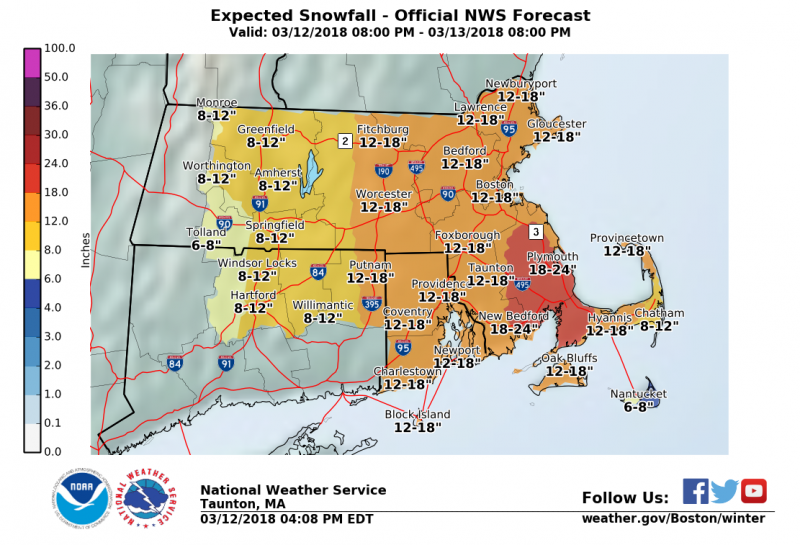
Update on Winter Storm Skylar

Here is an update from the National Weather Service.
Winter Storm Warning Remains in Effect from 11 p.m. tonight until 8 p.m. Tuesday.
Areas in Southeastern Massachusetts could see up to two feet of snow.
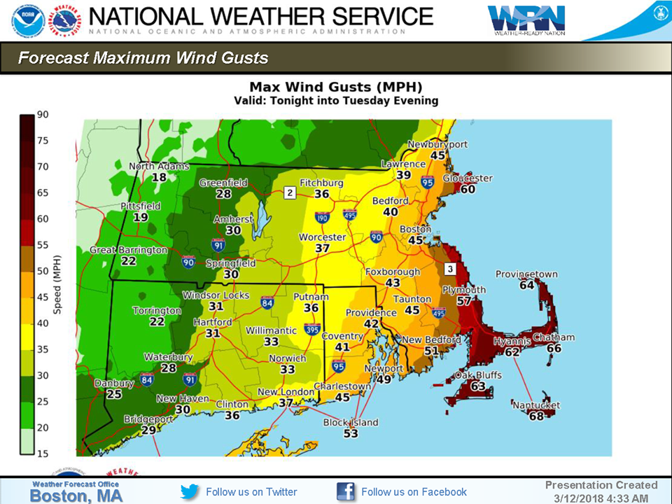
Strongest winds overnight into early Tuesday afternoon.
-50 to 65 mph wind gusts along the immediate eastern MA Coast/Cape and Islands.
– 40 to 50 mph wind gusts across interior eastern MA/RI.
-Isolated tree damage/isolated power outages with the greatest risk along the immediate eastern MA coast, Cape/Islands.
– High impact for the marine community with 45 to 60 knot wind gusts and 20+ foot seas on Tuesday.
Tonight A chance of rain showers before 10pm, then snow. Low around 31. Northeast wind 13 to 18 mph, with gusts as high as 29 mph. Chance of precipitation is 100%. New snow accumulation of 4 to 8 inches possible.
Tuesday
Snow, mainly before 5pm. The snow could be heavy at times. High near 35. Breezy, with a north wind 21 to 24 mph, with gusts as high as 39 mph. Chance of precipitation is 100%. New snow accumulation of 9 to 13 inches possible.


Tuesday Night
A chance of snow, mainly before 8pm. Cloudy, then gradually becoming partly cloudy, with a low around 30. West wind around 13 mph, with gusts as high as 29 mph. Chance of precipitation is 30%. New snow accumulation of less than a half inch possible.
Wednesday
A slight chance of snow showers before 11am, then a chance of rain showers. Partly sunny, with a high near 41. West wind 14 to 18 mph, with gusts as high as 29 mph. Chance of precipitation is 30%.
Wednesday Night
A slight chance of rain showers before 9pm, then a slight chance of snow showers between 9pm and 2am. Mostly cloudy, with a low around 30. Chance of precipitation is 20%.


You must be logged in to post a comment Login