

Community
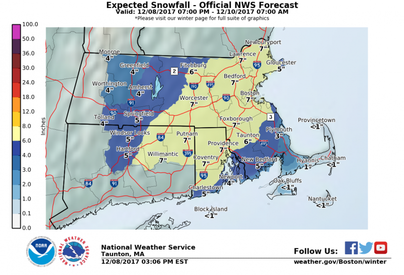
Snow totals raised ahead of Saturday storm
Its going to be snowy with some rain mixed in from Saturday morning until Sunday morning.
Its going to be snowy with some rain mixed in from Saturday morning until Sunday morning.
According to the National Weather Service in Taunton, a Winter Weather Advisory is in effect from 4 a.m. Saturday to 7 a.m. Sunday.
Plan on difficult traveling conditions tomorrow for portions of northern Connecticut, eastern, southeastern and western Massachusetts and northern and southern Rhode Island.
The forecast according to NWS Taunton:

Tonight: A chance of snow, mainly after 4am. Cloudy, with a low around 32. Southwest wind 5 to 7 mph becoming calm after midnight. Chance of precipitation is 30%. Total nighttime snow accumulation of less than a half inch possible.
Saturday: Snow before 4pm, then rain and snow. High near 34. Calm wind becoming north 5 to 9 mph in the morning. Chance of precipitation is 80%. New snow accumulation of 2 to 4 inches possible.
Saturday Night: Rain and snow, becoming all snow after midnight. Low around 32. North wind around 10 mph, with gusts as high as 21 mph. Chance of precipitation is 80%. New snow accumulation of 1 to 3 inches possible.
Sunday: A chance of snow before 7am, then a chance of snow showers between 7am and 11am. Cloudy through mid morning, then gradual clearing, with a high near 42. West wind 10 to 17 mph, with gusts as high as 28 mph. Chance of precipitation is 30%. New snow accumulation of less than a half inch possible.


You must be logged in to post a comment Login