

Community
Precipitation, strong winds begin this weekend across Southern New England
The National Weather Service is predicting a good amount of precipitation this weekend, but not much of it will be snow. We are also expected to see possibly damaging winds starting Sunday night.
Saturday night into Sunday …
A wintry mess is forecast across much of Southern New England. A brief burst of snow and sleet followed by a longer period of freezing rain, especially across the interior and away from the coastline. Greater concern is ice accretion on all surfaces beginning Saturday night into the first-half of Sunday. Hazardous travel impacts. At times, reductions to visibility.
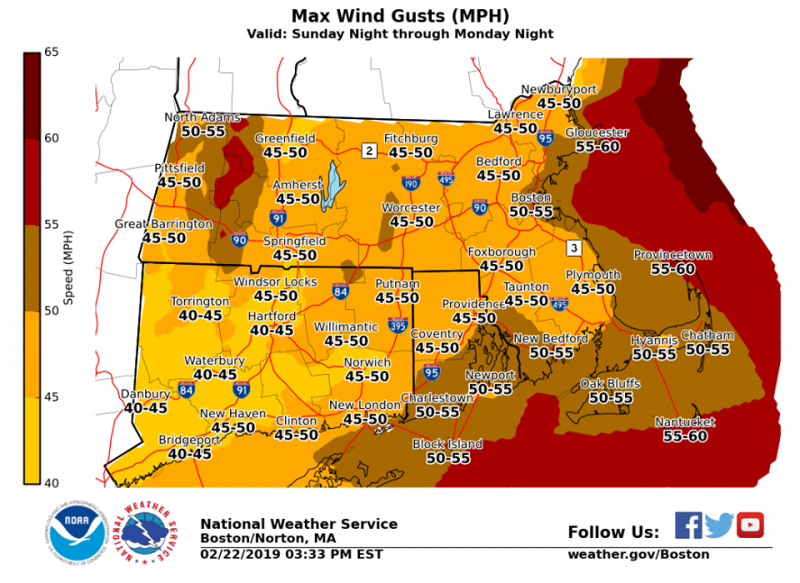
Sunday night through Monday night …
Strong, damaging winds, especially around Monday. Forecasting wind gusts of 35 to 45 mph, possibly in excess of 50 mph. Anticipated impacts of power outages and blocked roadways due to downed trees and/or tree limbs. Wind headlines are likely.

The forecast:
Saturday Night
A chance of snow and sleet between midnight and 3am, then a chance of rain after 3am. Increasing clouds, with a low around 30. Calm wind becoming southeast around 5 mph after midnight. Chance of precipitation is 50%. Little or no snow and sleet accumulation expected.
Sunday
Rain, mainly before 5pm. High near 49. Southeast wind 7 to 9 mph becoming southwest in the afternoon. Chance of precipitation is 90%. New precipitation amounts between three quarters and one inch possible.
Behind Sunday’s storm system, strong to damaging winds are forecast, starting Sun PM and peaking Monday afternoon. Highest wind gusts 45-55 mph, with possible gusts up to 60 mph. Impacts of downed tree limbs/trees as well as power lines. Power outages are possible.


You must be logged in to post a comment Login