

Community
Winter Storm Watch issued as nor’easter snow forecast beginning to take shape
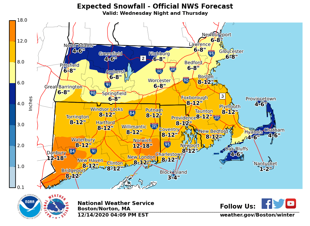
A winter storm is expected to arrive for most of the region later Wednesday into Thursday. There is still uncertainty as to how close to New England it will pass, which will determine how much snow we receive, however preliminary snow totals have been released.
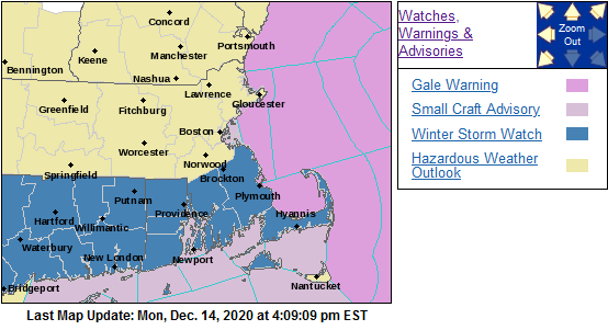
Northern Connecticut, Rhode Island and southeastern Massachusetts have been issued a Winter Storm Watch from Wednesday evening through Thursday afternoon by the National Weather Service.
Travel could be very difficult. The hazardous conditions could impact the Thursday morning commute.
The storm could bring heavy snow, strong winds along the coast, and coastal flooding and beach erosion to eastern Massachusetts.
Heavy snow and strong winds may occur along and west of the I-95 corridor, including Washington D.C., Philadelphia, New York City, and Boston metropolitan areas.
According to the NWS, the storm track is still not totally clear. If it passes farther offshore than shown in the map below, it would produce the most snow along the south coast, Cape Cod, and Islands with less snow farther to the north. A closer track would bring heavy snow to most of southern New England.
Minor coastal flooding is expected during high tide Thursday afternoon along the eastern Massachusetts coast. There is a low chance of seeing moderate flooding, primarily from Plymouth County to the bay side of Cape Cod, but that is unlikely right now.

Power outages are also possible.
The current forecast:
Tonight
A chance of rain and snow, mainly before 7pm. Cloudy during the early evening, then gradual clearing, with a low around 29. West wind 5 to 9 mph. Chance of precipitation is 30%. New snow accumulation of less than a half inch possible.
Tuesday
Sunny, with a high near 35. Northwest wind 7 to 9 mph, with gusts as high as 22 mph.
Tuesday Night
Partly cloudy, with a low around 20. North wind around 7 mph.
Wednesday
A slight chance of snow after 4pm. Mostly cloudy, with a high near 31. Northeast wind 6 to 8 mph.
Wednesday Night
Snow. Low around 27. Northeast wind 10 to 16 mph, with gusts as high as 28 mph.
Thursday
Snow likely, mainly before 9am. Mostly cloudy, with a high near 32. North wind 15 to 18 mph, with gusts as high as 28 mph.


Debra Machado
December 14, 2020 at 6:58 pm
what a vague weather report, says noting about the nor’easter.