

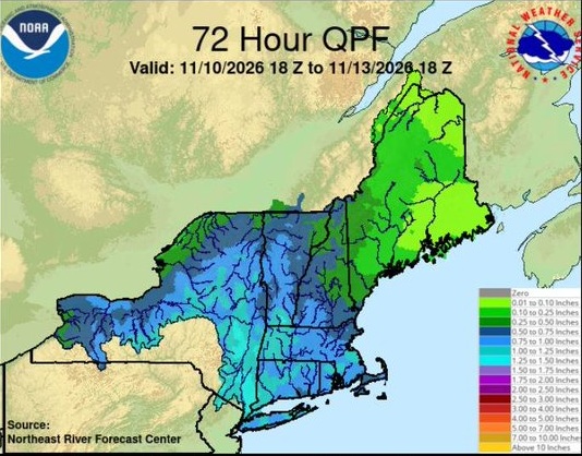
The National Weather Service in Boston/Norton is monitoring a potential storm system that could affect Massachusetts, Rhode Island, and Connecticut later this week, though significant uncertainty remains regarding its exact track and timing.
The National Weather Service Boston/Norton office, ensemble guidance continues to show large uncertainty in the development of a possible storm heading into the late week and weekend. Model tracks for the low pressure system range anywhere from Maryland to Nova Scotia. The European and Canadian ensembles, along with their AI counterparts, have trended toward a track near or slightly south of the 40N/70W benchmark, while the GFS ensemble shows paths closer to the southern New England coast.
Despite the track uncertainty, most guidance indicates the low will deepen into the mid-990 millibar range by early Friday morning. Temperatures at the 850 mb level are also expected to drop below freezing across southern New England by Friday evening. This supports a chance for some snow to mix in Friday and Friday night, primarily across higher elevation areas.
The National Weather Service notes only a 30-50% chance of 1 inch or more of snow in the higher terrain, with the highest probabilities along the eastern slopes of the Berkshires. The probability of 3 inches or more is less than 20%. These probabilities assume a 10:1 snow-to-liquid ratio. Forecasters add that unless heavy precipitation rates occur—which is considered highly unlikely—accumulations would likely be lower due to wetter snow. Any winter weather impacts in the higher elevations are expected to be very limited to none, consistent with low probabilities of minor winter storm impacts on the Probabilistic Winter Storm Severity Index.
For most of the region, including the coastal plain and larger population centers, the primary precipitation type is expected to be rain. Aviation and marine outlooks highlight the potential for rainy conditions, with windy weather and gusts up to 30-35 knots possible Friday into Saturday. Seas could become rough, reaching up to 12 feet offshore.
Looking ahead, the low is expected to push farther into Atlantic Canada during the second half of the weekend. High pressure is then forecast to build over the Mid-Atlantic region, bringing a return to blustery and dry conditions to southern New England by the start of next week.
The National Weather Service emphasizes that details remain uncertain and subject to change as the system approaches.