Community
Massachusetts and Rhode Island expected to see plowable snow early this week

Southern New England’s next snowstorm is expected early this week.
According to the National Weather Service Boston, a weak coastal low will bring light snow to the region on Tuesday morning and into Tuesday evening.
A widespread 1-3 inches is possible with localized areas of 4 inches. Closer to Cape Cod and the Islands, rain likely mixes in with snow due to temperatures that are expected to be above freezing.
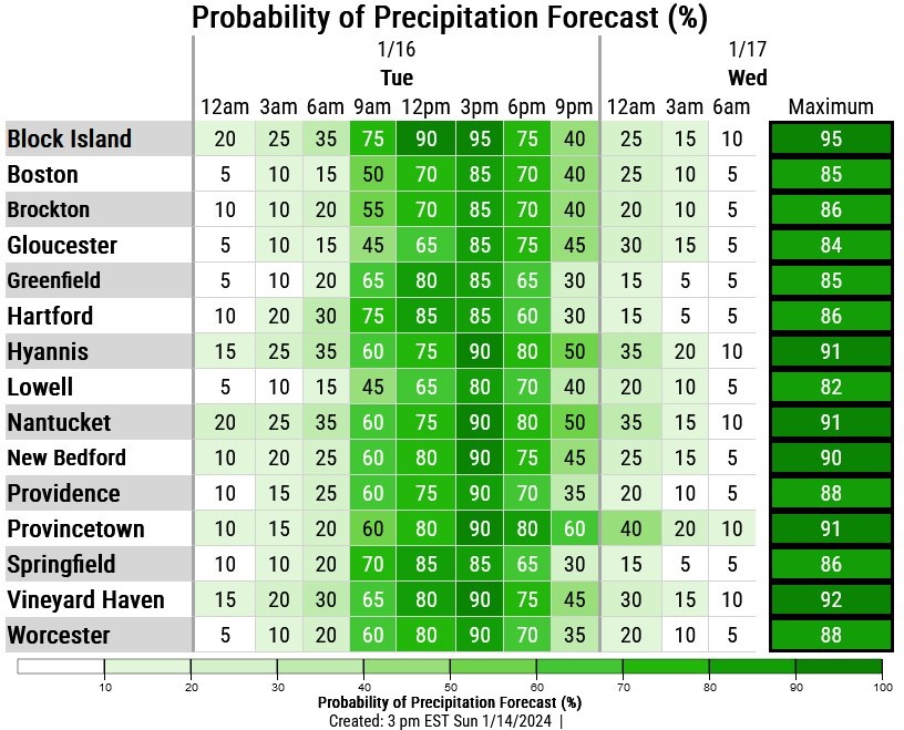

The forecast:


Monday Night
A slight chance of snow after 3am. Mostly cloudy, with a low around 22. West wind around 6 mph becoming calm in the evening. Chance of precipitation is 20%.
Tuesday
Snow, mainly after 9am. High near 35. East wind 5 to 9 mph becoming north in the afternoon. Chance of precipitation is 90%. New snow accumulation of 1 to 2 inches possible.
Tuesday Night
Snow likely, mainly before midnight. Mostly cloudy, with a low around 19. Northwest wind around 10 mph. Chance of precipitation is 60%. New snow accumulation of less than a half inch possible.

You must be logged in to post a comment Login