

Community
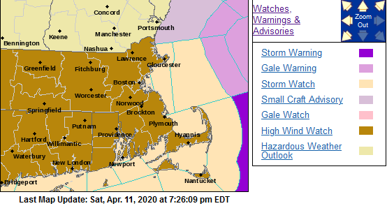
High Wind Watch issued ahead of upcoming storm
Strong winds with showers and possible thunderstorms are headed our way.
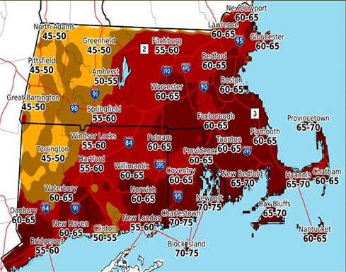
According to the National Weather Service, the area will experience south winds 25 to 40 mph with gusts up to 75 mph possible in portions of northern Connecticut, central, eastern, northeastern, southeastern and western Massachusetts and northern and southern Rhode Island.
The High Wind Watch is in effect from 8:00 a.m. Monday morning until 11:00 p.m. Monday night.
Damaging winds could blow down trees and power lines. Numerous power outages are possible. Travel could be difficult, especially for high profile vehicles.
The National Weather Service recommends fastening loose objects or shelter objects in a safe location prior to the onset of winds.

The forecast:
Sunday
Increasing clouds, with a high near 59. Light southwest wind becoming south 8 to 13 mph in the morning.
Sunday Night
A chance of showers, mainly after 3am. Mostly cloudy, with a low around 48. South wind 9 to 13 mph. Chance of precipitation is 30%. New precipitation amounts of less than a tenth of an inch possible.
Monday
Showers. High near 60. Windy, with a south wind 16 to 21 mph increasing to 23 to 28 mph in the afternoon. Winds could gust as high as 50 mph. Chance of precipitation is 100%. New precipitation amounts between three quarters and one inch possible.
Monday Night
A chance of showers and thunderstorms before 11pm, then a slight chance of showers between 11pm and midnight. Some of the storms could produce gusty winds. Mostly cloudy, with a low around 47. Breezy, with a south wind 17 to 22 mph decreasing to 8 to 13 mph after midnight. Winds could gust as high as 49 mph. Chance of precipitation is 50%.


You must be logged in to post a comment Login