

Community
Heavy Rain, Damaging Winds and Flooding Forecast for Sunday and Monday
A powerful storm is forecast to impact Massachusetts starting Saturday night and lasting into Monday, with the strongest impacts being on Sunday into Monday.
A powerful storm is forecast to impact Massachusetts starting Saturday night and lasting into Monday, with the strongest impacts being on Sunday into Monday.
We have High Wind Watch from Sunday at 6:00PM to 6:00 PM Monday
We have a Storm Watch from 6:00PM Sunday to 6:00AM Monday
We also have a Flash Flood Watch from 6:00AM Sunday to 6:00AM Monday
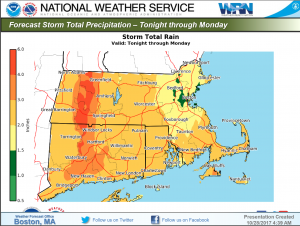
Rain will start tonight in western Massachusetts and spread across the entire state on Sunday. 1” to 3” of rainfall is forecast for most of the state, but some areas, particularly in Western Massachusetts may see 4” to 5”. The heaviest period of rain will be Sunday into Sunday night. Flash flooding in urban and poor drainage areas is possible, and there is a threat of small stream flooding in Western Massachusetts. There is a low risk of main stem river flooding starting on Monday. A Flash Flood Watch has been issued for all of Massachusetts.

Localized severe thunderstorms with isolated lightning strikes are possible, particularly on Sunday afternoon into Sunday night.
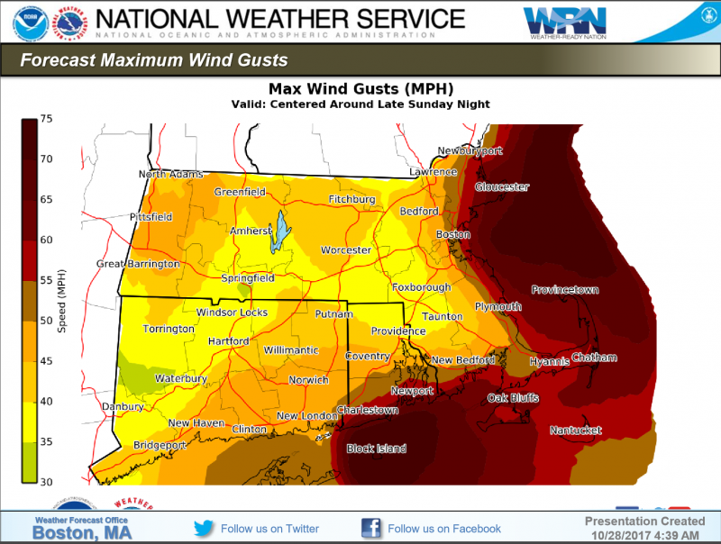
All of Massachusetts will experience strong and potentially damaging winds Sunday night into Monday – – all areas of the state will experience gusts of 35 MPH to 45 MPH – – but the strongest winds and greatest threat for damage being will be in eastern and southeastern coastal areas where winds may gust from 50 MPH to 70 MPH Sunday night and 40 MPH to 55 MPH on Monday. The National Weather Service is forecasting widespread damage to trees and numerous power outages. Isolated structural damage is possible. A High Wind Watch has been issued for all of Massachusetts.
Damaging winds may result in downed trees and limbs, numerous power outages, and isolated structural damage. The heaviest winds and associated damage will be in coastal areas and the Cape and Islands.
Flash flooding in urban and poor-drainage areas is possible, especially in western Massachusetts where the rain will be the heaviest. Small stream flooding is possible starting Sunday and there is a low risk of minor flooding along main stem rivers starting on Monday.
Thunderstorms and lightning strikes are possible.


You must be logged in to post a comment Login