

Community
Freezing rain, flash freeze, low wind chills expected Sunday into Monday
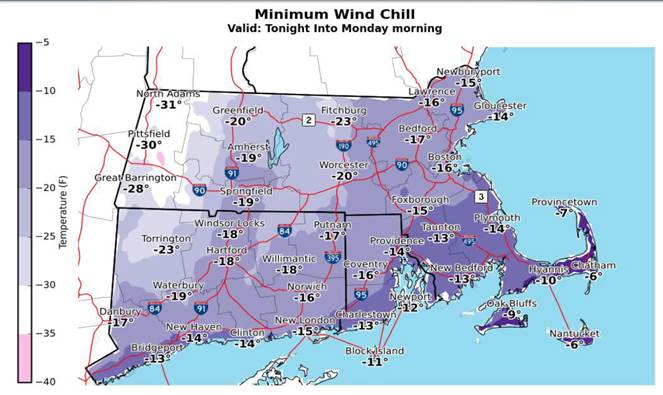
According to the National Weather Service, expect freezing rain and a flash freeze today with wind chills in the minus by late tonight and tomorrow morning.
Plan on slippery road conditions. Temperatures rise above freezing this morning, but this will be followed by a flash freeze between noon and 5 pm.
Today
Rain before 1pm, then rain or freezing rain between 1pm and 2pm, then freezing rain likely after 2pm. The rain could be heavy at times. Temperature falling to around 22 by 5pm. Northeast wind around 9 mph becoming southeast in the afternoon. Winds could gust as high as 21 mph. Chance of precipitation is 100%. New precipitation amounts between three quarters and one inch possible.

Tonight
A chance of sleet, possibly mixing with freezing rain after 7pm, then gradually ending. Cloudy, then gradually becoming partly cloudy, with a low around 4. Wind chill values as low as -12. Northwest wind 13 to 15 mph, with gusts as high as 30 mph. Chance of precipitation is 30%. Little or no sleet accumulation expected.
M.L. King Day
Increasing clouds and cold, with a high near 10. Wind chill values as low as -14. Northwest wind 13 to 15 mph, with gusts as high as 31 mph.
Monday Night
Mostly cloudy, then gradually becoming clear, with a low around 4. Wind chill values as low as -14. Northwest wind 11 to 15 mph, with gusts as high as 30 mph.


You must be logged in to post a comment Login