

Community
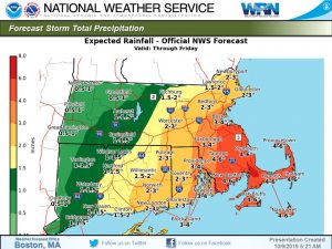
Flood Watch issued as some areas could see as much as 8 inches of rain
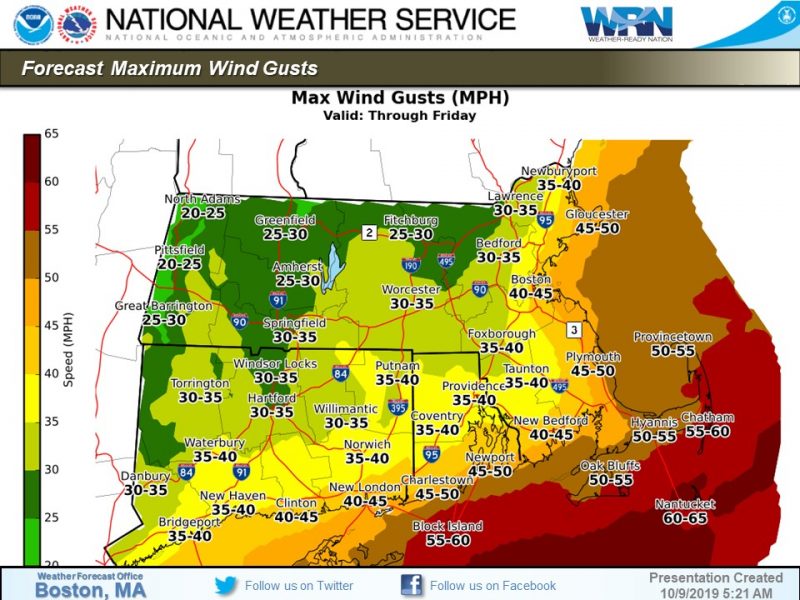
The coastal storm this week appears to be stronger than first thought.
The National Weather Service in Boston/Norton has issued a Flood Watch for a portion of southeastern Massachusetts, including the following areas, Barnstable, Bristol, Dukes, Nantucket, and Plymouth from this evening through Friday morning
A long duration heavy rainfall event will impact southeast MA and the Cape and Islands through Friday. Periods of rain today, then bands of heavy rain will move in from the ocean tonight and Thursday and persist into Friday. Storm total rainfall of 3 to 6 inches is expected through Friday with the heaviest rain across Plymouth county and Cape Cod. There is a low risk for localized rainfall amounts up to 8 inches.
Significant urban and poor drainage flooding is likely.
A Flood Watch means there is a potential for flooding based on current forecasts.

STRONG TO DAMAGING WINDS, potential for scattered power outages especially with trees remaining fully leaved.
INLAND FLOODING, especially across E/SE MA and RI with the potential for urban, poor drainage flooding. The significant potential along the coast with high tides and forecast surge.
COASTAL FLOODING, over several high tide cycles with a forecast 1.5 to 2.5 surge and waves building 15 to 25 feet on the outer waters. Impacts especially for SE-coastal MA. Beach erosion anticipated.
MARINERS, dangerous boating conditions. NE winds building today, the height of the gusts late Thursday into Thursday night around 35 to 55 kts.


You must be logged in to post a comment Login