

Community
As strong coastal storm approaches, wind advisory issued for area
The National Weather Service has issued an update for the strong coastal storm expected to hit our area.
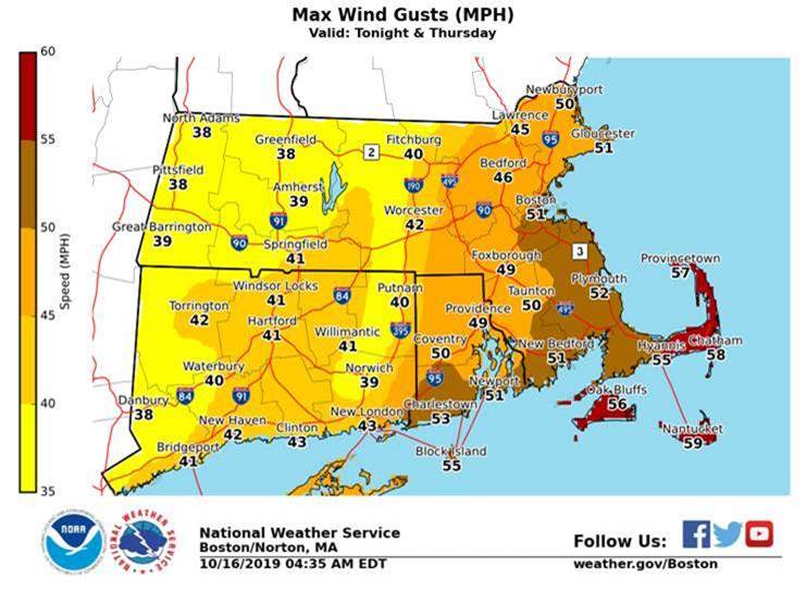
High Wind Watch – Cape Cod & Islands Thursday
Wind Advisories – south coast of RI and eastern MA coast including Boston tonight then all of RI and eastern MA Thursday which expires at 6:00 p.m.
Strong to Damaging Wind Threat …
When – two surges of wind are expected with the first surge tonight (east winds) followed by a stronger surge Thursday morning and afternoon (west winds)
Where – RI into eastern MA but strongest wind over Cape Cod and Islands
Impacts – winds potentially strong enough to down tree limbs and result in power outages. Greatest threat over Cape Cod and the Islands

Uncertainty – how much strong wind aloft will mix down to the surface and areal extent. Trees remaining fully leaved will require less wind for damage to occur.
Heavy Rainfall Threat & Poor Drainage Flooding …
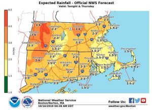
When – Heaviest rain approximately 10 pm Wednesday to 6 am Thursday from southwest to northeast
Where – all of MA, RI and CT
Impacts – a widespread 1.5 to 3 inches of rain with localized amounts of 4 to 5 inches possible. Given the relatively recent dry weather river and stream flows are running at or below normal. Therefore the only flooding expected is poor drainage/urban-street flooding. What may minimize any flooding impacts is the heaviest rainfall is expected to occur in between rush hours, after the late day commute today and before the Friday morning commute
Uncertainty – areal extent of 4 to 5 inch rainfall amounts are uncertain. Low and high end rainfall maps attached along with mostly likely rainfall amounts to help communicate this uncertainty


You must be logged in to post a comment Login