
Community
As Hurricane Dorian strengthens, news for Southeast US and the Bahamas worsens
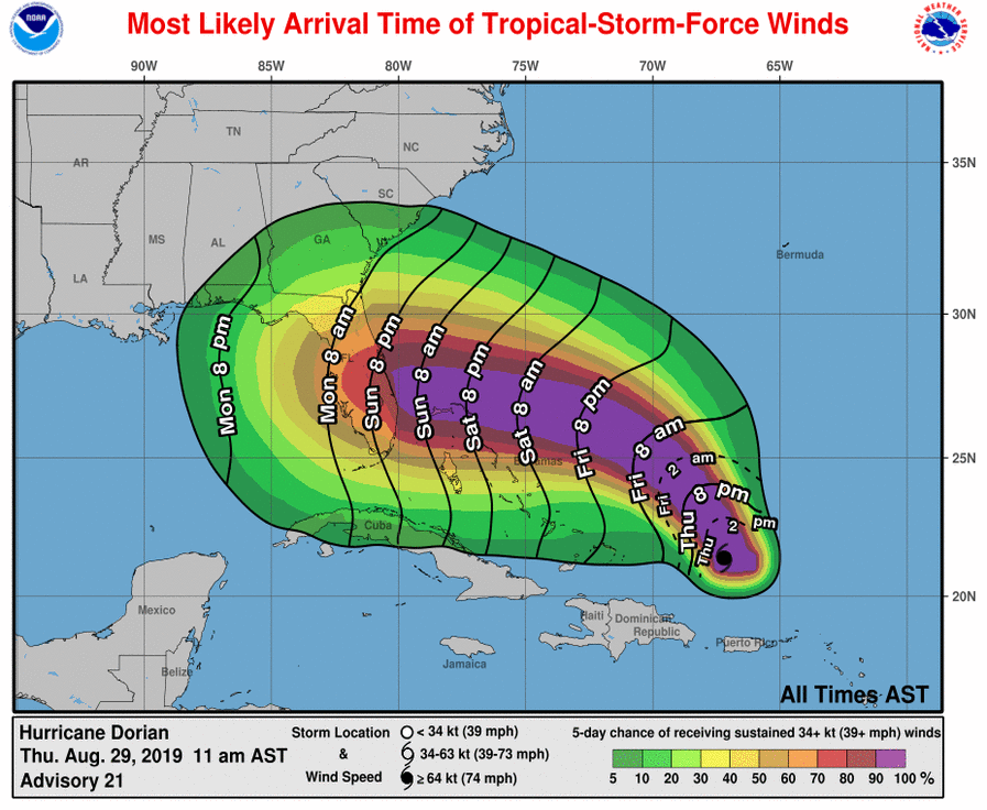
The NOAA NWS National Hurricane Center has issued an update on Hurricane Dorian and the news isn’t good for the Southeast United States.
Hurricane Dorian is centered as of 11 a.m. AST/EDT about 370 miles (600 km) east of the Southeast Bahamas. Dorian is moving toward the northwest near 13 mph (20 km/h), and this general motion is expected to continue through Friday. A west-northwestward motion is forecast to begin by Friday night and continue into the weekend. On this track, Dorian should move over the Atlantic well east of the southeastern and central Bahamas today and on Friday, approach the northwestern Bahamas Saturday, and move near or over portions of the northwest Bahamas on Sunday.
Maximum sustained winds are near 85 mph (140 km/h) with higher gusts. Hurricane-force winds extend outward up to 15 miles (30 km) from the center and tropical-storm-force winds extend outward up to 90 miles (150 km). Strengthening is forecast during the next few days, and Dorian is expected to become a major hurricane on Friday, and remain an extremely dangerous hurricane through the weekend.

Dorian is expected to produce the following rainfall accumulations this weekend into early next week:
The central Bahamas…1 to 2 inches, isolated 4 inches.
The northwestern Bahamas…3 to 6 inches, isolated 8 inches.
Coastal sections of the Southeast United States…4 to 8 inches, isolated 12 inches. This rainfall may cause life-threatening flash floods.
The risk of devastating hurricane-force winds along the Florida east coast and peninsula late this weekend and early next week continues to increase, although it is too soon to determine where the strongest winds will occur.


You must be logged in to post a comment Login