

Community
With negative wind chills starting the weekend, significant snow totals updated for upcoming storm in Massachusetts, Connecticut, Rhode Island
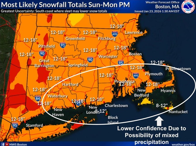
As wind chills as low as -20 are expected to start the weekend, a clearer picture of snow accumulations for the upcoming storm has been revealed for Massachusetts, Rhode Island, and Connecticut, ahead of a Winter Storm Watch in effect from Sunday morning to Monday evening.
Above is a look at the National Weather Service’s initial “Most Likely Snow Accumulation” forecast for the winter storm expected to impact southern New England.
Keep in mind, this can and will be refined/changed as things come into better focus over the next 24-48 hours.

Snow starts late Sunday morning/early Sunday afternoon. The period of heaviest snow (chance for 1+”/hour) is Sunday evening into the first half of Sunday night. Snow then becomes lighter on Monday as it tapers off through the day from west to east.
Roads, and especially bridges and overpasses, will likely become slick and hazardous. Travel could be very difficult to impossible. The hazardous conditions could impact the Monday
morning and evening commutes.
People should delay all travel if possible. If travel is absolutely necessary, drive with extreme caution and be prepared for sudden changes in visibility. Leave plenty of room between you and the motorist ahead of you, and allow extra time to reach your destination. Avoid sudden braking or acceleration, and be especially cautious on hills or when making turns. Make sure your car is winterized and in good working order.