

Community
National Weather Service issues snowfall ranges for upcoming storm in Massachusetts, Rhode Island, Connecticut
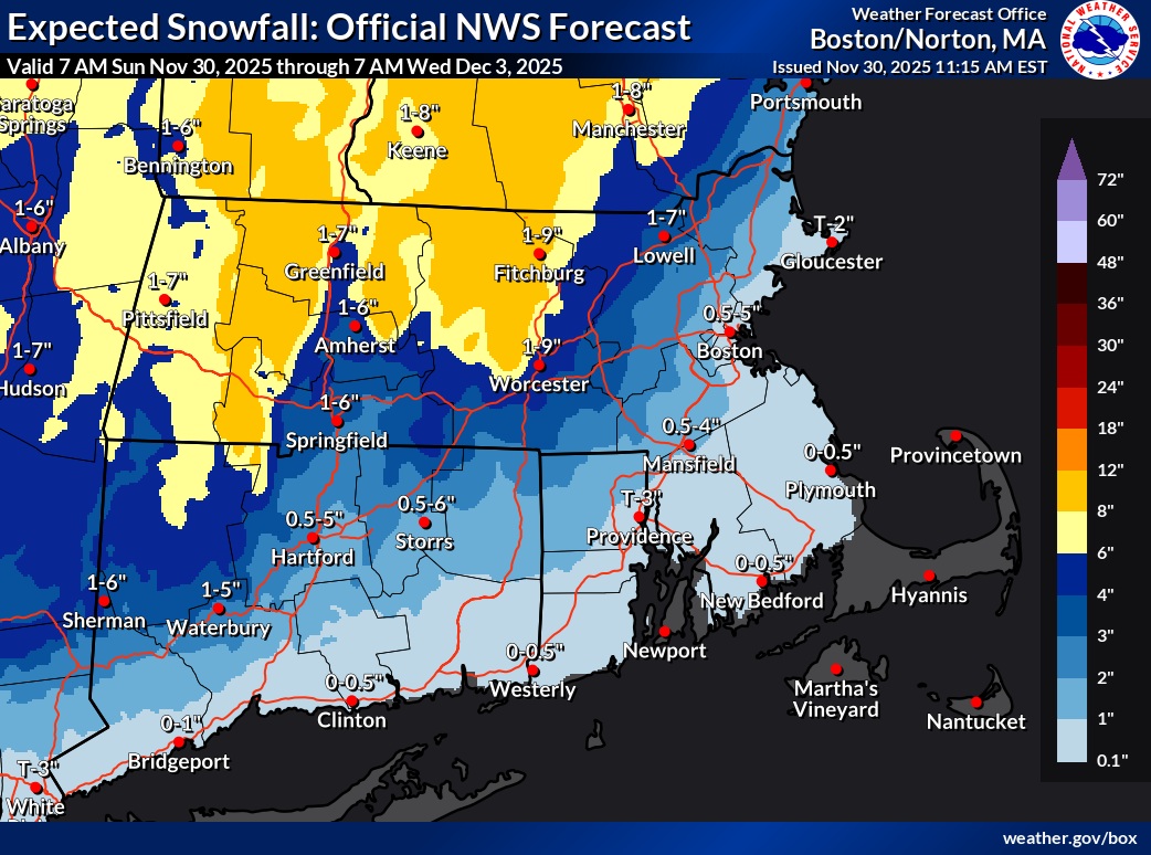
While there continues to be some uncertainty on how much snow Massachusetts, Rhode Island, and Connecticut residents will receive, forecasters have issued snow fall ranges and forecast guidance ahead of an upcoming storm.

According to the National Weather Service, a coastal low-pressure system will bring substantial precipitation to southern New England Tuesday into Tuesday Night, with the potential for a plowable/shovelable snow for interior southern New England
Significant detail differences continue to impact the forecast for a low pressure passing by our region Tuesday into Tuesday night. Some of the latest guidance suite notably the GFS and Canadian, have trended their tracks farther north. This time being inside of the 40N/70W benchmark. Meanwhile, other members continued to linger near or south of that point. With no blocking high over Quebec to trap low level cold air across southern New England, the track and timing details will greatly impact temperatures. Minor changes to temperatures around freezing will have a major impact on precipitation type, and ultimately snowfall accumulations.
The latest NationalBlend data continued to show some mixed messages, highlighting the remaining uncertainty. While uncertainty decreased across portions of central and western MA and northern CT, uncertainty increased across eastern MA. The 50 percent confidence interval for 24-hour snowfall ending 7 AM Wednesday lowered to 4-5 inches, while across eastern MA it increased to 10-14 inches. Expecting changes almost up to the last minute with this particular event.
NWS continues to have the greatest confidence in accumulating snowfall across the higher terrain of the northern Worcester Hills and east slopes of the Berkshires. Still no certainty on the amounts. However, there are moderate probabilities (50-70%) for at least 3 inches of snowfall, and about a 30-45% chance for 6 or more inches of snowfall. The probabilities only go down from there towards the I-95 corridor between Boston and Providence, about 30-45% for at least 3 inches of snowfall and 15-25% for at least 6 inches of snowfall.


