

Community
Massachusetts, Rhode Island, Connecticut forecast to receive accumulating snow, ice, and rain
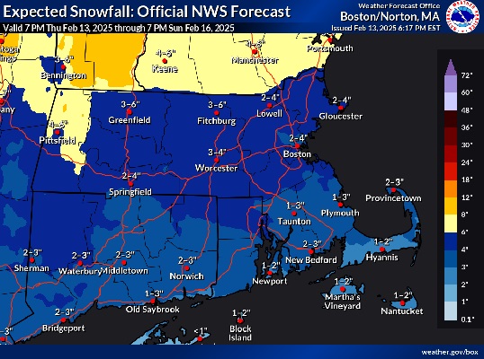
Snow, ice, and more rain are headed to Massachusetts, Rhode Island, and Connecticut in the coming days.
According to the National Weather Service, dry, windy & colder weather returns tonight & Friday, however, the next system results in accumulating snow later Saturday into Saturday night…that will eventually change to ice/rain by Sunday. Some areas could see 4 or more inches of snow.
The forecast:
Tonight
Areas of fog before 7pm. Otherwise, mostly cloudy during the early evening, then gradual clearing, with a low around 26. Breezy, with a west wind 11 to 20 mph, with gusts as high as 36 mph.
Friday
Sunny, with a high near 33. West wind 15 to 18 mph, with gusts as high as 37 mph.
Friday Night
Partly cloudy, with a low around 14. Northwest wind 6 to 14 mph.

Saturday
Snow likely, mainly after 5pm. Mostly cloudy, with a high near 32. Calm wind becoming southwest around 6 mph in the afternoon. Chance of precipitation is 60%. New snow accumulation of less than one inch possible.
Saturday Night
Snow before 1am, then snow and sleet between 1am and 3am, then freezing rain after 3am. Low around 25. Calm wind becoming east around 6 mph after midnight. Chance of precipitation is 100%. New snow and sleet accumulation of 2 to 4 inches possible.
Sunday
Rain. High near 42. East wind 9 to 11 mph, with gusts as high as 22 mph. Chance of precipitation is 100%.
Sunday Night
Rain and snow likely before 11pm, then a chance of snow between 11pm and midnight. Mostly cloudy, with a low around 21. West wind 9 to 16 mph, with gusts as high as 28 mph. Chance of precipitation is 70%.


