
Community
Heavy rain, strong, damaging winds expected across parts of Massachusetts, Rhode Island, Connecticut
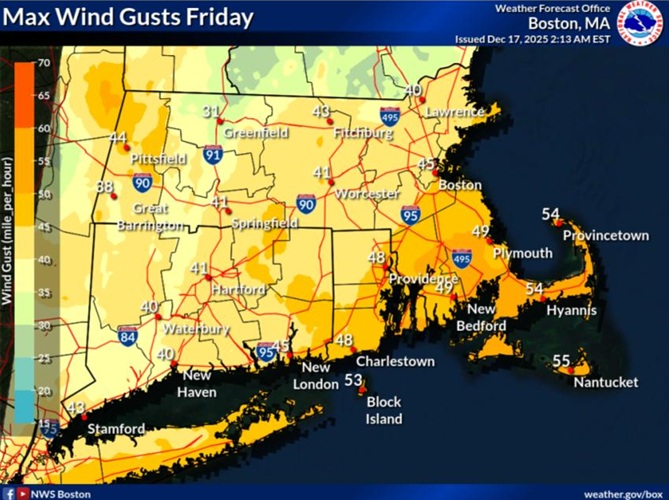
A period of locally heavy rainfall, strong to damaging wind gusts and unseasonably mild temperatures are expected across parts of Massachusetts, Rhode Island, and Connecticut.
According to the National Weather Service, wind gusts to 50 to 60 mph will develop over the Cape and Islands Friday morning and lingering into the early afternoon with wind gusts to 40 to 50 mph expected for the rest of eastern Massachusetts and Rhode Island on Friday morning.
A period of locally heavy rainfall will also impact southern New England from west to east late Thursday night into early Friday afternoon.
Another surge of strong west wind gusts is expected Friday night as much colder air pours into the region.
The forecast:
Today
Partly sunny, then gradually becoming sunny, with a high near 45. Southwest wind 11 to 14 mph, with gusts as high as 32 mph.
Tonight
Mostly clear, with a low around 26. West wind 5 to 8 mph becoming calm after midnight. Winds could gust as high as 22 mph.

Thursday
Sunny, with a high near 52. Calm wind becoming south 5 to 9 mph in the afternoon.
Thursday Night
Rain likely, mainly after 3am. Increasing clouds, with a low around 42. South wind 7 to 15 mph, with gusts as high as 32 mph. Chance of precipitation is 70%.
Friday
Rain, mainly before 4pm. High near 57. Breezy, with a south wind 15 to 23 mph, with gusts as high as 49 mph. Chance of precipitation is 100%.
Friday Night
A chance of rain, mainly before 8pm. Partly cloudy, with a low around 25. West wind around 15 mph, with gusts as high as 32 mph. Chance of precipitation is 30%.


