

Community
Forecasters issue update on what to expect in Massachusetts, Rhode Island, and Connecticut Nor’easter
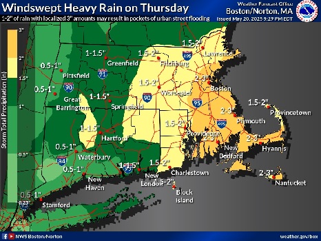
Massachusetts, Rhode Island, and Connecticut are expected to see heavy rains and strong winds in the coming days.
According to the National Weather Service, a late season Nor’easter will bring heavy rain and strong winds along the coast Thursday into -Thursday night.
1-2″ of rain with localized 3″ amounts may result in pockets of poor drainage street flooding. Northeast winds may gust to between 40 & 50 mph on the coast.

The foreast:
Tonight
Patchy drizzle after 11pm. Mostly cloudy, with a low around 47. Northeast wind 7 to 9 mph.
Wednesday
Patchy drizzle between 11am and 3pm. Mostly cloudy, with a high near 57. Northeast wind around 11 mph.
Wednesday Night
A chance of rain, mainly after 8pm. Cloudy, with a low around 47. East wind 9 to 11 mph. Chance of precipitation is 40%. New precipitation amounts of less than a tenth of an inch possible.

Thursday
Rain. The rain could be heavy at times. Patchy fog before 8am. High near 52. East wind 14 to 17 mph, with gusts as high as 37 mph. Chance of precipitation is 100%. New precipitation amounts between 1 and 2 inches possible.
Thursday Night
Rain, mainly before 4am. Low around 47. Northeast wind 10 to 13 mph, with gusts as high as 32 mph. Chance of precipitation is 100%.
Friday
A chance of rain before 8am, then a chance of showers, mainly between 8am and 3pm. Mostly cloudy, with a high near 59. Northwest wind around 10 mph, with gusts as high as 21 mph. Chance of precipitation is 40%.
Friday Night
A chance of showers after 8pm. Mostly cloudy, with a low around 47. Southwest wind around 6 mph. Chance of precipitation is 30%.
Saturday
A chance of showers before 4pm. Partly sunny, with a high near 63. West wind 6 to 10 mph. Chance of precipitation is 30%.


