Community
As snow ends across Massachusetts, Rhode Island, and Connecticut, more is headed our way in the coming days
While today’s snow may have been a minor event for most in Massachusetts, Rhode Island and Connecticut, more of the white stuff is on the way.
According to the National Weather Service, after the couple inches of snow/sleet/rain which is expected to end this evening, several more inches of snow are expected this weekend throughout the area.
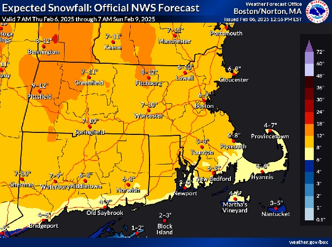
The above graphic combines the snow from today’s storm with this weekend’s storm.
Here is the forecast with the expected timeline of when the new snow will arrive.
This Afternoon
Snow and freezing rain, possibly mixed with sleet before 2pm, then freezing rain likely between 2pm and 3pm, then a chance of rain after 3pm. High near 35. East wind 6 to 10 mph, with gusts as high as 20 mph. Chance of precipitation is 100%. Total daytime snow and sleet accumulation of 1 to 3 inches possible.
Tonight
Mostly cloudy, with a low around 31. Southwest wind 5 to 9 mph.
Friday

Mostly sunny, with a high near 41. West wind 8 to 16 mph, with gusts as high as 30 mph.
Friday Night
Partly cloudy, with a low around 19. West wind 5 to 10 mph.
Saturday
Mostly sunny, with a high near 34. Northwest wind 5 to 7 mph.
Saturday Night
Snow, mainly after 11pm. The snow could be heavy at times. Low around 24. Calm wind becoming east around 5 mph after midnight. Chance of precipitation is 100%. New snow accumulation of 3 to 7 inches possible.
Sunday
Snow and sleet before 1pm, then a chance of snow between 1pm and 4pm. High near 36. East wind 6 to 10 mph becoming northwest in the afternoon. Winds could gust as high as 20 mph. Chance of precipitation is 90%.