Community
Whiteout conditions and potentially life-threatening travel possible in southern New England nor’easter. Here is the latest

Massachusetts/Rhode Island – As you may have heard, a nor’easter is approaching southern New England. Here is the latest information.
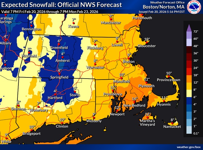
According to the National Weather Service, a Winter Storm Watch is in effect from late Sunday through Monday evening for south coastal Massachusetts and Rhode Island, including Cape Cod and the Islands.
Heavy snow is possible. Total snow accumulations of more than a foot are possible.
Whiteout conditions are possible at times and may make travel treacherous and potentially life-threatening.
Onset of the snow looks to be Sunday night, with the peak of the snowfall rates later Sunday night into Monday, before snow tapers off Monday evening. It`s possible dry air at onset could
cause snow to hold off until Monday, so it’s also not out of the question that the bulk of the snow could fall during the day Monday.
In addition to the snow, there is increasing confidence in seeing widespread 50-60 mph gusts on Cape Cod and the Islands and most of the coastal waters. High Wind Watches have been issued for Cape Cod and the Islands, with Storm Watches for the coastal waters. This will be a dangerous storm for mariners with potential for at least 25-foot seas offshore.
Finally, high astronomical tides Monday into Tuesday brings the potential for minor to moderate coastal flooding along eastern MA coast, depending upon timing of highest surge. Surge guidance and pattern recognition suggests a 3-foot surge around high tide early Monday morning and again early Tuesday morning, which could bring the water level to over 6 feet in Nantucket Harbor and to 13.5 feet in Boston, although wave impacts along the coastline would result in greater impacts (likely Moderate) as well as coastal erosion. Keep in mind large pressure falls would also add to the water level, so even a more offshore track could still result in significant coastal flooding.


