Community
System could bring accumulating snow, arctic temperatures, to Massachusetts, Rhode Island, Connecticut in coming days
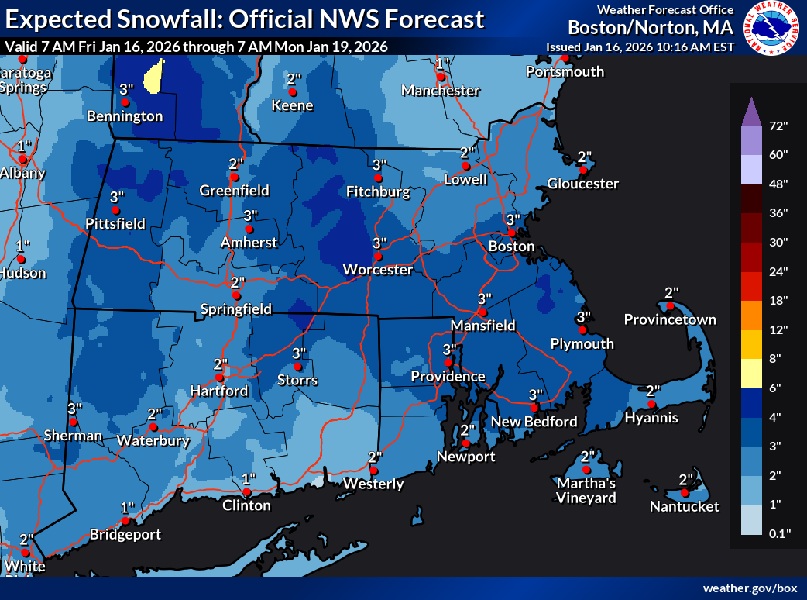
A system with currently quite a bit of uncertainty could bring accumulating snow and arctic temperatures to Massachusetts, Rhode Island, and Connecticut in the coming days.
According to the National Weather Service, 1 to 2″ of snow is expected very late tonight into Saturday across the lower elevations of interior Massachusetts and northern Connecticut. 2-4″ are possible across the higher terrain of the Berkshires and northern Worcester Hills. Guidance has continued to trend warmer for areas south and east of I-95 bringing boundary layer temps in the upper 30s and even lower 40s along the coastal plain. There still may be a slushy coating in these locations, but impacts will be limited.
After Saturday’s event, offshore low pressure may bring a plowable snow to portions of the region Sunday-Sunday night…but the westward extent remains quite uncertain.

There still remains considerable uncertainty with the westward extent of a potentially plowable snowfall in association with an offshore low pressure system Sunday into Sunday night. The National Weather Service doesn’t normally see this much spread in the guidance for a day 3 forecast…but there are so many moving parts. The 00z GFS/NAM/ECMWF operational models keep the low pressure far enough east that taken verbatim would result in very
little if any snow ever reaching as far northwest as the Boston to Providence corridor. However…it is more complex than that. They noted that some of the 00z GEFS ensembles have shifted further northwest. In addition…the 00z RGEM/UKMET were considerably further northwest and would bring accumulating snow all the way back cross distant interior southern New England. Also of note…is that he GFS/ECMWF AI models continue to be considerably west of the traditional GFS/ECMWF models. These AI models bring a plowable snowfall all the way back across interior southern New England.
So, in a nutshell…given all the uncertainty there probably is not a ton of value in a deterministic snowfall forecast Sunday into Sunday night. That being said…appears the greatest risk for a plowable snow might be near and southeast of the Boston to Providence
corridor. That possibility could extend back into western MA and CT if the western solutions verify. And it is also possible that there will be little if any snowfall even into the Boston to Providence corridor. NWS thinks they should see the models getting a much better handle on snow totals in the next 12-24 hours.
After Sunday’s possible event, an arctic cold front crosses the region later Monday, bringing well below normal temps, bitterly cold wind chills, along with Gales/Freezing Spray for our waters into Wednesday.